(1060) ENCLOSED HUT-GROUP (traces of), S.E. of Cwm-corun, appearing as a round levelled
area ca. 90 ft. in diameter, at 750 ft. above O.D., cut into ground falling genty
to the S.W.
Condition: almost destroyed. SH 40564519 23 ix 48 26 S.W. Unnoted.
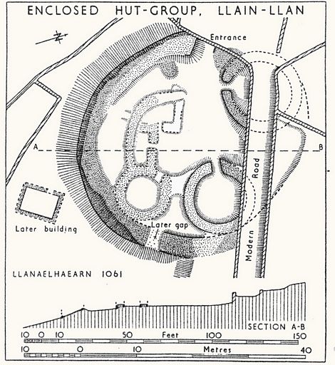
(1061) ENCLOSED HUT-GROUP near Llain-llan (Fig. 87) at 735 ft. above O.D. on
ground falling to the S.W. The group is cut into the ground on the N. and terraced
out to a height of 8 ft. on the S. The enclosing wall is 10-12 ft. thick, faced with
orthostats. The remains are generally in good condition, save that the N. side has
been destroyed bv a modem road and a break has been made through the enclosure-wall
on the E.........S. of the group is a later long hut, with walls 2 ft. 6 ins. thick
and high.
Antiquity. 1951, p. 180. Fig. 3.
Condition: ruined. SH 40764497
(1062) ROUND HUT, N. ofLlain-Uan, at 750 ft. above O.D.
on ground falling to the S.W. The hut is 26 ft. 4 ins. in diameter, with a wall 5
ft. 4 ins. thick and 2 ft. high, with good orthostadc facing on both sides. Condition:
good. SH 40854498 ii vi 46 26 S.W. Unnoted
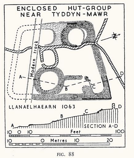
1063) HUT-GROUPS AND HUTS near Tyddyn-mawr, at 800 ft. above O.D. in ground falling
to the S.W. The best preserved feature is a trapezoidal enclosure (Fig. 88), containing
traces of three round and one or two sub-rectangular buildings. The site is much
ruined, but the enclosing wall appears to be ca. 5 ft. thick, of rubble faced with
orthostats; the entrance was probably on the S. A hundred yards N.W. of this group
are three huts appearing as hollows ca. 20 fr. in diameter;
30 yds E. of it is a rectangular terrace, ca. 130 ft. square, with traces of one
rectangular and two round huts; this is probably the site of another enclosed hut-group.
No stone walling remains except in the first hut-group.
The sites lie m an area of small early terraced fields covering ca. 14 acres (Fig.
89),
Condition: of fields, good; of huts, poor. SH 42684513 26 v 53 26 S.W.
Unnoted
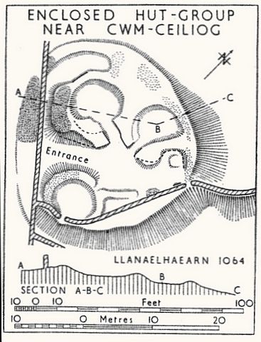
(1064) ENCLOSED HUT-GROUP near Cwmceiliog (Fig. 90), on the W. side of a valley at
800 ft. above O.D. A roughly circular enclosure apparently containing one or two
sub-rectangular and three circular buildings. It is bounded by a bank of earth and
small stones, the remains of a wall which survives only on the N.W. where it is 5
ft. thick. On the E. the bank follows the edge of a terrace 7 ft. high.
A system of small terraced fields (Fig. 91) extends N. and S. from the hut-group,
covering an area ofca. 5 acres berwcen the 800 and 900 ft. contours. The terraces
are 1-5 ft. in height.
Condition: much mined.
(1065) ENCIOSED HUT-GROUP near Galleyceiliog, at 600 ft. above O.D. on ground falling
to the N. A rectangular enclosure ca. 100 ft. by 70 ft.; the area is intersected
by modem field walls and partly obscured by a pile of loose stones. The enclosure
is visible as a slight bank, best preserved on the S., where it is 3 ft. high. There
are traces ot circular huts, each ca. 20 ft. in diameter, on the N.W. side, in the
W. corner and on the S.E. side; and possibly of other structures. Slight remains
of a system of lynchctted fields are visible below the hut-group. Condition: poor.
SH 37424558 1947 25 S.E. Unnoted
(1066) ROUND-HUT GROUP (remains of) near Pentre-bach at 550 ft. above O.D. An artificial
terrace ca. 60 ft. by 45 ft., cut into the slope of the hill, probably marks the
site of a hut-group to which a series of lynchetted fields on the S. and W, slopes
of Moelfre belonged.
Condition: destroyed.
33 N.W. Unnoted SH 39I5442I 1947