UNCLASSIFIED EARTHWORKS
(1053) STONE SETTINGS AND MOUND, at 850 ft. above O.D., on the saddle between Gym
Ddu and Moel Penllechog. Three rectangular enclosures, each ca. 30 ft. by 9 ft. and
bounded by a single line of small boulders, are situated ca. 30 yds. N. by W., 30
yds. W., and no yds. W. respectively from a small pond. The long axis of the first
points N.W. by N., and those of the other two N. Midway between the last two is a
mound, axis N. by W., ca. 40 ft. long, 6 ft. wide, and l ft. 6 ins. high. Condition:
fair. SH 39344624 26 v 53 26 S.W. Unnoted
(1054) PILLOW MOUNDS near Farm Yard, at 850 ft. above O.D. Two mounds 40 yds. apart,
rectangular in plan rising to a blunt axial ridge: (i) 35 ft. long, 12 ft. wide,
3 ft. high, (ii) 36 ft. long, 9 ft. wide, 2 ft. high. Condition: good. SH 40494564
1946 26 S.W. Unnoted
(1055) ENCLOSURES on the S.E. slopes of Gym Ddu, at 1300 ft. above O.D. A roughly
circular enclosure ca. 130 ft. in diameter lies on ground tailing steeply to the
S.E. The interior is not levelled but the lower side forms a low terrace. In general
the wall is reduced to a low bank of stones 4-8 ft. thick, but enough remains to
show that it was originally 3-4 ft. thick, with a core of small stones faced on both
sides with larger ones. On the N. is an entrance 6 ft. wide, the w.ill slightly incurved
on cither side. Adjoining the enclosure on the lower side is an annexe ca. 50 ft.
wide, its eastern part destroyed.
Arch. Camb., 1950, p. 40, No. 4. Condition: poor. SH 40704647 1946 26
S.W. Unnoted
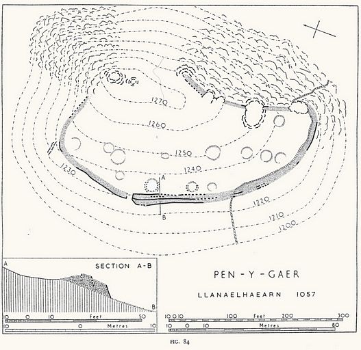
(1057) PEN-Y-GAER (Fig. 84), a small fort occupying the top of an isolated hill
rising to 1270 it. above O.D. The sides arc steep, with numerous rocky outcrops on
the summit and E. slopes. An ancient road leads towards the fort from the N.E. (see
p. Ixv).The defences consist of a single dry-built wall. Where best preserved, along
the W. side, it appears to have been about 15 ft. thick; the outer face has a pronounced
batter, and within the wall, about 5 or 6 ft. from the outer face, is an internal
face with a slighter batter. The inner face of the rampart is similar. The internal
faces, however, are only visible on the S.W. There is no evidence whether the rampart
is of one or two periods of construction.
The entrance, on the W., is a passage n ft. long and 7 ft. wide; the wall faces can
be traced on each side. On the S. at the entrance the outer face turns outwards and
die space between it and the embedded internal face increases to about 8 ft., so
that the end of the rampart is slightly clubbed. The ruins N. of the entrance may
conceal a similar arrangement.
Within the enclosure are about a dozen rather ill-defined terraced platforms, ca.
20 fc. in diameter, probably the sites of wooden huts. A small trench cut into one
in 1939 revealed occupation earth and a small potsherd (since lost).1
Arch. Camb., 1887, p. 252.l Unpublished information in Commission files. Condition:
good. SH 42874550 27 vii 56 26 S.W.
HUTS AND FIELD SYSTEMS
(1058-62) EARLY FIELDS AND DWELLINGS near Cwm-corun. The sides ot the valley in which
Cwm-corun stands are covered, between the 650 and 900 ft. contours, with well-marked
cultivation terraces. These lie mostly on land at present enclosed or cultivated;
they now appear as strip lynchets 100 to 200 ft. broad and up co 1000 ft. in length,
but it seems probable that cross-contour boundaries have been destroyed to build
modern walls. The Iynchets seem to fall into three groups. The first, near Llethr
Ddu, containing two interlocking sets of strips, is probably associated with hut-group
No. 1058; the second, stretching for 500 yds. between the 700 and 900 ft. contours
seems to be connected with Nos. 1059 and 1060; and the third, with tour strips extending
for 350 yds. between the 650 and 800 ft. contours, may belong to No. 1061.
The lynchcets are generally ca. 3 ft. high, but in (he last group they reach a height
ot ca. 10 ft.
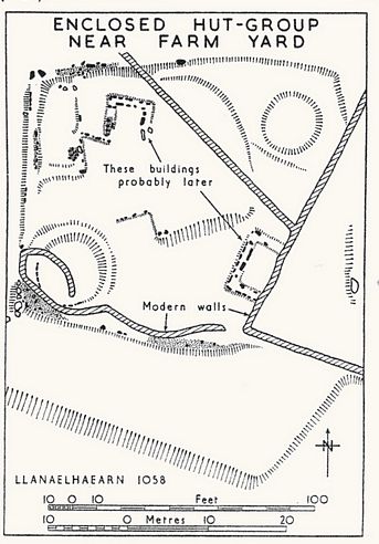
(1058) ENCLOSED HUT-GROUP near Farm Yard (Fig. >S5), at 850 ft. above O.D. on ground
falling gently to the S. Where best preserved the enclosing wall, of earth faced
with stone, stands i ft. 6 ins. high and is 4 ft. thick, but the site has been much
robbed. Condition: ruined. SH 40414570 22 ix 48 26 S.W. Unnoted
(1059) ENCLOSED HUT-GROUP E. of Cwm-corun (Fig. 86), at 850 ft. above O.D. on
ground falling generally to the S.W. The site has been much robbed, but the N. hut,
which is cur into the hillside, is fairly well preserved. The enclosure forms an
irregular pentagon. Condition: ruined. SH 40604540 28 ix 48 26 S.W. Unnoted